Rivers, Ruins & Ridge Lines: Chasing Lesser‑Known Routes Through the Southwest
The American Southwest is usually reduced to a postcard: one shot of the Grand Canyon, maybe another of Monument Valley, and that’s it. But just beyond those familiar overlook railings are canyons without names on most maps, pueblos where woodsmoke still threads the evening air, and dirt roads that end at riverside hot springs with no cell service and no selfie sticks. This is a journey stitched together from lesser‑known corners of Arizona, New Mexico, Utah, and Colorado—places you can actually breathe, wander, and watch the sky change without a crowd pressing in. Pack light, drive slow, and let the road bend your plans.
Sketching the Route: A Four‑State Loop of Quiet Places
Imagine landing in Albuquerque, picking up a small rental car or high‑clearance SUV, and tracing a loop that never quite touches the classic icons yet constantly brushes up against them. You head north along the Rio Grande, not to ski towns or resort spas, but to hot springs tucked into canyon walls and historic plazas humming softly at dusk. From there, you climb onto high desert mesas in northwest New Mexico, cross into southeast Utah’s sandstone labyrinth, then arc through southwest Colorado’s forested plateaus and Ancestral Puebloan sites before dropping back toward New Mexico’s volcanic fields and lava‑rimmed badlands.
This loop isn’t about ticking off “must‑see” spots; it’s about pacing your days around sunrise trailheads, long lunches in shady plazas, and sunset drives along two‑lane highways. With 7–10 days, you can link a string of short hikes, scenic drives, and small towns, layering archaeology, geology, and desert solitude. The key is flexibility: build a loose backbone of destinations, then leave blank space in your itinerary for detours down gravel roads and tip‑offs from locals.
High Desert Gateway: Albuquerque to the Quiet Rio Grande
Start in Albuquerque, but don’t rush for the interstate. The city is wrapped in landscape that changes fast: cottonwood‑lined river, volcanic cones, and the Sandia Mountains climbing over 10,000 feet in the east. Spend a first afternoon acclimating at Petroglyph National Monument, where short trails wind past volcanic boulders etched with centuries of rock art. It’s close to town yet feels like a threshold: the suburbs fall away, and suddenly you’re walking in silence broken only by wind and distant traffic.
From Albuquerque, follow the Rio Grande north on smaller roads instead of blasting up I‑25. Stop in the village of Corrales for a coffee and stroll along acequia‑fed orchards; then continue toward Española and the low‑key river towns that line the canyon. If you have time, detour into the Jemez Mountains via NM‑4, a sinuous highway that passes red rock walls, ponderosa forest, and roadside hot springs. It’s a preview of the trip’s rhythm: slow, scenic, with plenty of reasons to pull over and walk a little further than most visitors bother to.
Hot Springs and Old Plazas: Taos and the Northern New Mexico Backroads
Northern New Mexico is full of front‑of‑postcard destinations—Taos, the High Road villages—but you can still carve out your own quiet pockets. Base yourself in or near Taos for two nights, then fan out on day trips. At sunrise, head for the Rio Grande Gorge, where the river has cleaved a basalt plateau into a sheer‑walled canyon. Instead of just snapping photos from the bridge, hunt for lesser‑known trailheads along the rim and side arroyos. Many of these paths are unmarked but well‑trod by locals, leading to lofty viewpoints and, in some cases, riverside hot springs tucked beneath cliffs.
In the afternoons, trade dirt for adobe. Wander the Taos Plaza and the surrounding side streets, then aim for outlying communities like Arroyo Seco—or farther afield along the High Road to villages such as Truchas and Chimayó. These are places where art studios, chapels, and small cafes are woven into centuries‑old communities. The key is a soft footprint: park once, explore on foot, and support family‑owned spots. Between canyon hikes and slow village circuits, you’ll start to feel the pattern of the trip—the daily swing between wildness and human stories.
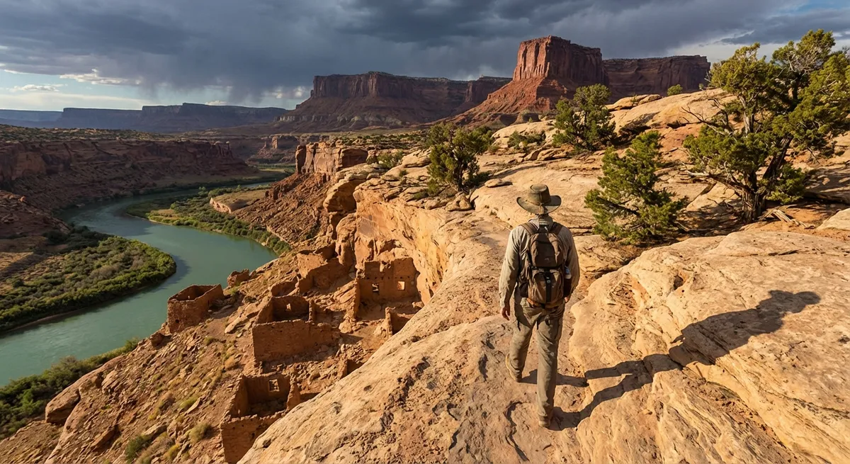
Into the Sandstone Maze: Northwest New Mexico to Southeast Utah
From Taos, steer west toward the wide, empty miles of northwest New Mexico. This is a land of eroded badlands, high mesas, and long views; gas stations thin out, and your fuel gauge suddenly matters. Plan for a midday grocery stop in a larger town (Farmington or Bloomfield) to re‑stock water, snacks, and fresh food before you head deeper into the red rock country.
Crossing into Utah, the landscape shifts from rolling plateaus to sculpted sandstone. Instead of racing to Zion or Arches, aim for less heralded corners of the Colorado Plateau—places like the BLM (Bureau of Land Management) zones along Highway 95 or side canyons branching off the San Juan River corridor. Here, signed trailheads might be nothing more than a small pullout and a faint path arrowing into slickrock and juniper. These “under‑the‑radar” routes often deliver big scenery—arches, pouroffs, alcoves—without the tour bus crowds. Check land agency websites in advance for road conditions and closures, and keep in mind that a single storm can turn dirt tracks into clay traps.
Ruins Above the Canyons: Mesa Country in Southwest Colorado
Bending northeast into Colorado, the sandstone gives way to higher, greener mesas. This is a chance to layer your trip with time and memory. The best‑known Ancestral Puebloan sites get justified attention, but the region is dotted with lesser‑visited ruins, cliff dwellings, and mesa‑top villages managed by the National Park Service, tribes, and the Bureau of Land Management. Reservations or timed entries may be required for some tours, while others can be seen from short, quiet trails.
Use a town like Cortez, Dolores, or Mancos as your base. Mornings are ideal for exploring archaeological sites: cooler temperatures, softer light for photography, and smaller crowds. Afternoons can be for forest drives along the mesas’ edges, lakeside picnics, or riverside paths as temperatures climb. The striking thing here is verticality; you’ll spend a lot of time on the rim of something, peering down into canyons carved over millennia. Take the time to read interpretive signs and, when offered, join ranger‑led walks—understanding who lived here, and when, deepens every trail you hike.
Volcanic Horizons and Quiet Canyons: Southbound Through Western New Mexico
Heading south back into New Mexico, the terrain morphs yet again. Lava fields, cinder cones, and wide grasslands take over from red rock towers. Volcanic parks and monuments in this region often fly under the radar, even though they’re right off major routes. Short trails across ancient lava flows, up cinder cones, or along rim views offer fast, high‑reward adventures as you return toward Albuquerque.
Schedule one last evening in a small town along the way, where you can walk through a modest historic district after dinner and watch the sky turn cobalt behind distant mesas. This is your decompression zone: a final chance to re‑calibrate to human time before flights and inboxes intrude again. Often, these low‑key final nights become surprise highlights—conversations with locals, discovering a mural‑covered alley, or sitting in a tiny park listening to train horns echo across the plains.
Packing for Heat, Height, and Sudden Weather Swings
This loop crosses elevations from roughly 4,000 to over 10,000 feet, and the weather can turn in minutes. Packing smart lets you embrace last‑minute hikes or road detours without worrying about what’s in your bag. Think in flexible layers rather than separate “desert” and “mountain” outfits. A lightweight base layer, a breathable long‑sleeve sun shirt, and a compact insulating layer (synthetic or lightweight down) can handle chilly dawns and gusty viewpoints. Top it off with a windproof, water‑resistant shell that packs into its own pocket.
Footwear matters more than most other items. Choose broken‑in, low‑to‑mid hiking shoes with decent tread and toe protection; you’ll be walking on slickrock, loose scree, and dusty trails. Pair them with moisture‑wicking socks and keep a spare pair in your daypack for emergencies or surprise river crossings. A wide‑brim hat, UV‑blocking sunglasses, and a buff or bandana are essential for sun and dust. For hydration, carry at least 2–3 liters of water in a bladder or bottles, even on short hikes—trailheads are often remote, and shade can be scarce.
Practical Trail Gear: Streamlined, Desert‑Ready Essentials
You don’t need a thru‑hiker’s kit to explore this route, but a few intentional choices can transform each outing. A 20–30 liter daypack with a supportive hip belt is your rolling base camp: big enough for water, layers, and lunch, small enough to toss in the backseat. Add a small first‑aid kit tailored to the desert (blister care, antihistamines, electrolyte packets, sunscreen, and a basic bandage setup) and a compact headlamp—even if you don’t plan on being out after dark. Sunset hikes are tempting, and trails can be tricky to follow in the half‑light.
Navigation is a blend of analog and digital. Download offline maps for your entire loop before you leave strong Wi‑Fi and carry a simple paper map for big‑picture orientation. Many less‑trafficked trails are unsigned or have confusing social paths; a combination of downloaded topo maps and watching the terrain will keep you oriented. Trekking poles can be helpful on steep, loose sections, particularly in canyon country, but are optional if you’re confident on uneven ground. Toss in a lightweight emergency bivy or space blanket—not because you plan to use it, but because remote areas reward redundancy.
A Sample 7‑Day Itinerary for the Restless and Curious
Use this as a flexible framework, not a rigid checklist. Swap days, trade drives, and adjust distances based on your pace.
- **Day 1: Albuquerque Arrival & Petroglyphs**
Land, pick up your vehicle, and walk an evening loop at Petroglyph National Monument. Overnight in Albuquerque.
- **Day 2: Rio Grande North & Taos Base**
Follow the Rio Grande north with stops in Corrales and small river towns; arrive in Taos by late afternoon. Sunset stroll through town. Overnight in or near Taos.
- **Day 3: Gorge Hikes & High Road Villages**
Early hike along the Rio Grande Gorge, then an afternoon drive on the High Road, visiting historic churches and small galleries. Second night in Taos.
- **Day 4: West to Red Rock Country**
Drive west through northwest New Mexico, stock up in a larger town, then continue toward southeast Utah. Short sunset hike near your base for the night.
- **Day 5: Sandstone Canyons & Scenic Byways**
Spend the day exploring lesser‑known trails and viewpoints off secondary highways. Consider a half‑day canyon hike and then a slow scenic drive. Overnight in a small Utah town.
- **Day 6: Ruins & Mesa Views in Southwest Colorado**
Cross into Colorado to explore mesa‑top archaeological sites via short hikes and scenic loops. Overnight in Cortez, Dolores, or Mancos.
- **Day 7: Volcanic Detour & Return South**
Angle south through western New Mexico, stopping at volcanic monuments or lava fields for brief hikes before finishing in Albuquerque. Evening flight out or one last night in the city.
This outline leaves plenty of white space to insert hot springs soaks, extra hikes, and spur‑of‑the‑moment detours toward intriguing side roads.
Travel Logistics: Seasons, Safety, and Slow‑Road Strategy
Timing shapes your experience more than any single destination. Spring and fall usually offer the friendliest balance of temperature, trail conditions, and daylight, though shoulder seasons can also bring unpredictable storms. Summer heat narrows your hiking window to early morning and late afternoon; winter can leave higher passes and mesa‑top roads icy or temporarily closed. Check road and trail conditions frequently through official park and transportation sites, especially after heavy rain.
Remote doesn’t mean reckless. Always top off fuel in larger towns and keep a physical note of distances between services along your route. Let someone know your general plan and expected return times for longer day hikes. Afternoon thunderstorms can build quickly, especially over mountains and high mesas—if clouds start towering and darkening, avoid high, exposed ridges and slot canyons where flash floods are possible. In more populated zones, be patient with slower traffic and pullouts; locals use these roads daily, and your trip is more fun if everyone gets where they’re going safely.
Traveling Lightly: Respecting Land and Story
The Southwest’s open spaces can feel infinite, but they’re exquisitely fragile. Cryptobiotic soil—the dark, lumpy “living crust” that holds desert ecosystems together—can be destroyed by a single bootprint, taking decades to recover. Stay on durable surfaces: rock, dry washes, established trails. Inside archaeological sites, never touch the walls, sit in rooms, or move artifacts; oils from skin, and even the slight pressure of a hand, contribute to long‑term damage. Pack out every scrap of trash, including food waste that might seem “biodegradable.”
Equally important is how you move through living communities. Many pueblos and tribal lands have photography rules, closed areas, or seasonal restrictions; these are not obstacles but expressions of sovereignty and cultural continuity. Ask politely before taking photos of people or ceremonies, follow posted guidelines without argument, and spend your money in local businesses when you can. Traveling this way—curious, careful, and generous—turns a road trip into a respectful exchange rather than a drive‑through experience.
Conclusion
The glow of the Southwest isn’t limited to its famous overlooks. It’s in the way early light rakes across a basalt mesa, in the soft clink of cups in a village cafe, in the hush of a canyon side trail that never shows up on top‑ten lists. By stringing together hidden hot springs, quiet ruins, and modest main streets, you build a journey that feels personal rather than prescribed. Pack light, walk often, and leave gaps in your days for the unexpected bend in the road—that’s where the real Pinecrest View of this landscape waits.
Sources
- [National Park Service – Petroglyph National Monument](https://www.nps.gov/petr/index.htm) – Official information on trails, regulations, and cultural significance near Albuquerque
- [New Mexico Tourism Department – North Central Region](https://www.newmexico.org/places-to-go/regions/north-central/) – Overview of Taos, High Road villages, and Rio Grande recreation opportunities
- [U.S. Bureau of Land Management – Utah Recreation](https://www.blm.gov/programs/recreation/recreation-activities/utah) – Maps, access details, and safety information for exploring lesser‑known Utah public lands
- [National Park Service – Mesa Verde National Park](https://www.nps.gov/meve/index.htm) – Background on Ancestral Puebloan sites, permits, and ranger‑led programs in southwest Colorado
- [Centers for Disease Control and Prevention – Healthy Travel in the United States](https://wwwnc.cdc.gov/travel/destinations/traveler/none/united-states) – Guidance on hydration, heat, altitude, and general health precautions for domestic travelers